Showing 48 items matching historic precinct
-
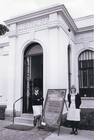
 Flagstaff Hill Maritime Museum and Village
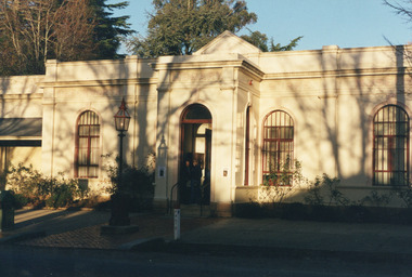
Artwork, other - Etching, Eric Tonkin, Flagstaff Hill Warrnambool, 1985
... historic precinct flagstaff hill lighthouse...The etching depicts the Historic Precinct of Flagstaff Hill...The etching depicts the Historic Precinct of Flagstaff Hill ...The etching depicts the Historic Precinct of Flagstaff Hill Maritime Museum and Village. It includes the building that were transferred from Middle Island to Flagstaff Hill in the early 1870s; Lighthouse, Keepers' Quarters, Chart Room.Depiction of historic buildings at Flagstaff Hill, Warrnambool, part o f the History of Warrnambool. The artist is a local citizen.Etching of Flagstaff Hill Lighthouse complex - artist Eric Tonkin. Picture shows the Chartroom, Lighthouse Keeper's Quarters, Assistant's Quarters, Privy and Flagstaff. Framed behind glass, black and gilded frame. Sticker and inscriptions on the back."Rec No 389A" "FLAGSTAFF HILL" Etching by Eric Tonkin, 34 Howard St, Warrnambool, Ph 62 4707"flagstaff hill, warrnambool, etching, flagstaff hill lighthouse complex, artist eric tonkin, historic precinct flagstaff hill lighthouse, eric tonkin, flagstaff hill maritime museum and village, lady bay lighthouse, lighthouse keeper's quarters, chart room -
 The Beechworth Burke Museum
Photograph
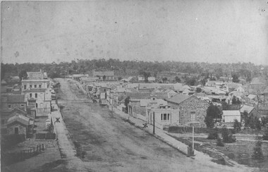
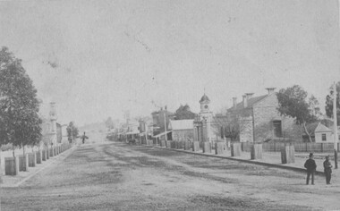
... beechworth historic precinct... know as Beechworth Historic precinct and includes The Gold... Historic precinct and includes The Gold Wardens office being ...Taken in Beechworth 1859, this photograph depicts Ford Street looking South West. On the left hand side is now what we know as Beechworth Historic precinct and includes The Gold Wardens office being the first building in view followed by The Chinese Protectors office, The Gold Vault and The Courthouse. The Telegraph station is out of shot in this image.his image of Ford Street is the first council chambers copy known to exist.Black and white rectangular photograph. Image is printed on matte photographic paper. Obverse: NO INSCRIPTION Reverse: 2827 AO2827 See Tibbets 'Beechworth Historical Reconstruction page 53" FORD ST BEECHWORTH LOOKING S/WEST 1859burke museum, ford street, council chambers, beechworth historic precinct -
 Stawell Historical Society Inc
Photograph, Bicycle Display at Stawell Historical Society C 2019, 2019
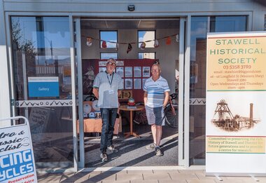
... historic Precinct Gallery... historic Precinct Gallery David Francis & Greg Robson in front ...David Francis & Greg Robson in front of Bicycle display set up by David a Member of Stawell Historical SocietyGreg Robson & david Francis in doorway of Pleasant Creek historic Precinct Gallerysports -
 The Beechworth Burke Museum
Photograph - Postcard, Town Hall Beechworth, c1910
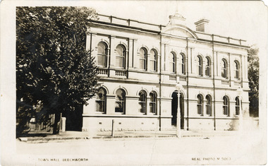
... Beechworth Historic Precinct... Precinct historic precinct Harry Power Bushranger Australian ...Beechworth Town Hall was designed by architects J.J. Coe and Thomas Dalziel and is dated to 1859. The building was made of granite and constructed to local builders Donald and William Fiddes. The original front to the building was replaced by a two story facade in 1889 designed by George Jobbins and built by Thomas Sandham according to a plaque on the front. The Town Hall is remarkable for its vaulted ceilings and columns. Originally the building was used as the Shire Offices but also doubled as a fire station and a courthouse, with still surviving cells underneath. Among the inmates was notorious bushranger Harry Power who was originally transported to Van Dieman’s Land for stealing a pair of shoes. He gained his freedom six years later but spent time in and out of gaol for the rest of his life for a variety of offences including a number of armed robberies. The Town Hall is now home to the Visitor Information Centre which helps visitors with amongst other things, accommodation, tours, event enquiries, and is the commencement point for Precinct walking tours. The Beechworth Town Hall is one of five distinctive granite buildings on Ford Street that comprise the Justice Precinct. It is of considerable historical significance as activity on the site dates from Australia’s gold rush period and was the administrative centre for north-eastern Victoria. The building has seen continual use from 1858 as an important public building and displays many aspects of the history of law enforcement in Victoria. The building is also of substantial architectural significance for its construction from local honey coloured granite, which also showcases early stone masonry techniques and craftsmanship. The Precinct is listed on the Victorian Heritage register and is protected by Heritage Victoria under the Victorian Heritage Act 2017. The buildings are also registered by the National Estate, the National Trust and protected by Indigo Shire Council’s Planning Scheme. Black and White rectangular postcard printed on cardReverse: 1906-1910?beechworth, beechworth town hall, town hall, jj coe, thomas dalziel, granite, beechworth historic building, courthouse, cells, geoge jobbins, thomas sandham, 1859, 1889, walking tours, beechworth historic precinct, historic precinct, harry power, bushranger, australian bushrangers, van dieman's land, transportation, armed robberies -
 The Beechworth Burke Museum
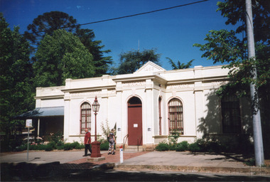
Photograph, Unknown
... beechworth historic precinct... and Cultural Precinct, one of Australia’s best preserved historic-town ...This undated photograph depicts two people standing in the vestibule entrance at the Burke Museum, Beechworth. The museum site dates to the 1857 founding of the Beechworth Public Library and Athenaeum by a newly formed Young Men's Association (YMA). In 1863 the museum was dedicated as a memorial to former Beechworth police superintendent (1854-1858) and explorer Robert O’Hara Burke, following Burke’s death from malnutrition on the Burke and Wills expedition in 1861. Funded by the Victorian Government and the Royal Society of Victoria, the officially titled 'Victorian Exploring Expedition' was tasked with being the first European party to traverse Australia from south to north. The Burke Museum holds objects from the famous expedition and explores the multi-layered history of Beechworth and surrounds from the gold rush era to the present.This photograph is historically significant for its depiction of the Burke Museum and Loch Street streetscape. The Burke Museum is Australia’s oldest regional museum and part of Beechworth's Historic and Cultural Precinct, one of Australia’s best preserved historic-town sites and a popular tourist destination. Once the government centre for a vast gold fields region, this collection of nationally significant buildings tells the story of how Australia grew and prospered. The frequent use of honey-coloured local granite as a building material, which can be seen in the museum's fabric, gives Beechworth’s historic buildings a distinct and cohesive local character. This photograph may be compared and studied alongside other images of historic buildings in the Burke Museum Photographic Collection.Rectangular colour photograph printed on photographic paper.Reverse: 3440burke museum, beechworth athenaeum, beechworth library, beechworth historic precinct, robert o'hara burke, australia's oldest regional museum, indigo shire, beechworth athanaeum, beechworth historic building, historic precinct, honey-coloured local granite, victorian gold fields, historic towns in victoria, victoria's high country, colonial australia, beechworth tourism, things to see in beechworth, beechworth historic trail, historic victorian architecture, burke and wills expedition, first europeans to cross australia, young men's associations -
 The Beechworth Burke Museum
Photograph, 1869
... beechworth historic precinct... ford street council chambers beechworth historic precinct tree ...Taken in Beechworth 1869, this photograph depicts the Council Chambers on Ford Street. This phtograph was taken by James E. Bray who was well known for being one of four men to photograph the Kelly gang after the siege of Glenrowan. Black and white rectangular photograph mounted on card.Obverse: NO INSCRIPTION Reverse: BMM2969 / 23 / 76-1 / Taken 1869 / Showing Council Chambers / Built 1860 / burke museum, ford street, council chambers, beechworth historic precinct, tree guards, james e. bray -
 The Beechworth Burke Museum
Photograph, 1856
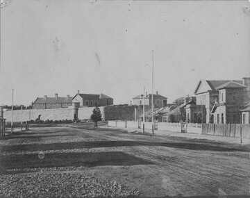
... beechworth historic precinct... and Telegraph Station. burke museum ford street beechworth historic ...Taken in Beechworth 1856, this photograph depicts Ford Street featuring, from the background to the foreground; the Old Beechworth Goal, the Gold Wardens Office, Chinese Protectors Office, Gold Vault, Courthouse and Telegraph Station.Black and white rectangular photograph mounted on card. Reverse: 1997.3089 / 84-207-1 / Streets / GAOL AND COURTHOUSE / TELEGRAPH OFFICE / BEECHWORTH 1865 burke museum, ford street, beechworth historic precinct, gaol, courthouse, telegraph station, gold wardens office, gold vault, chinese protectors office -
 The Beechworth Burke Museum
Photograph, c1999-2000
... historic precinct... of Beechworth's Historic and Cultural Precinct, one of Australia’s best ...This photograph taken c1999/2000, depicts the Burke Museum’s granite façade and vestibule entrance. The museum's large red door is closed and there is a white sign is attached to the door. The museum site dates to the 1857 founding of the Beechworth Public Library and Athenaeum by a newly formed Young Men's Association (YMA). In 1863 the museum was dedicated as a memorial to former Beechworth police superintendent (1854-1858) and explorer Robert O’Hara Burke, following Burke’s death from malnutrition on the Burke and Wills expedition in 1861. Funded by the Victorian Government and the Royal Society of Victoria, the officially titled 'Victorian Exploring Expedition' was tasked with being the first European party to traverse Australia from south to north. The Burke Museum holds objects from the famous expedition and explores the multi-layered history of Beechworth and surrounds from the gold rush era to the present.This photograph is historically significant for its depiction of the Burke Museum c1999/2000. The Burke Museum is Australia’s oldest regional museum and part of Beechworth's Historic and Cultural Precinct, one of Australia’s best preserved historic-town sites and a popular tourist destination. Once the government centre for a vast gold fields region, this collection of nationally significant buildings tells the story of how Australia grew and prospered. The frequent use of honey-coloured local granite as a building material, which can be seen in the museum's fabric, gives Beechworth’s historic buildings a distinct and cohesive local character. This photograph captures this distinctive character and may be compared and studied alongside other images of historic buildings in the Burke Museum Photographic Collection.Rectangular colour photograph printed on photographic paper.Reverse: 7031 / Label: Burke Museum / 1999/2000 /burke museum, indigo shire, beechworth athanaeum, beechworth library, beechworth historic building, historic precinct, burke museum exhibition, from the liedertafel to the skating rink, honey-coloured local granite, robert o'hara burke, victorian gold fields, historic towns in victoria, colonial australia, liedertafel, colonial entertainments, beechworth brass band, historic victorian architecture, australia's oldest regional museum, burke and wills expedition, first europeans to cross australia, yound mens associations, beechworth tourism, things to see in beechworth, beechworth historic trail, young men's associations -
 The Beechworth Burke Museum
Photograph, c.1980
... beechworth historic precinct... museum beechworth historic precinct architecture museum library ...This photograph depicts the entrance to the Burke Museum in Beechworth, most likely in 1980. The building was originally established as the Beechworth Athenaeum in 1857 to provide a lecture hall and reading room at the peak of the gold rush. In 1859, it became the Beechworth Public Library, which is why the writing embossed above the main entry says 'Library' rather than 'Museum'. The building was turned into a museum and renamed the Robert O'Hara Burke Memorial Museum in 1863 in honour of Robert O'Hara Burke, former Police Superindendent of Beechworth who died in 1861 on the Burke and Wills expedition. The Burke Museum has been in almost continual operation since that time. In the 1970s, the building underwent renovations to create several verandas, though the main façade visible in this photograph remained as it was when originally built. The Burke Museum currently contains over 30,000 individual objects, including the Gold Rush era items and the Ned Kelly collection advertised on the a-frame in the photograph. The photograph itself is also part of the Burke Museum collection.The Burke Museum itself is very significant to Victorian history. It is on both the Victorian Heritage Register and is part of the National Trust due to its relevance to the history of the Gold Rush period, its architectural features, and its significant collection. Photographs of it throughout its history are an important part of telling the museum's story. This photograph in particular highlights what the museum staff believed would be appealing to a 1980s public, evident by the A-frame advertising board.A black and white rectangular photograph printed on photographic paper.Top right text: 5147. Bottom left text: Beryl Seatt (or possibly Scatt) & friend 1980beechworth, burke museum, beechworth museum, beechworth historic precinct, architecture, museum, library, 1980s, 1980s australia, museum staff -
 Glenelg Shire Council Cultural Collection
Photograph - Photograph - Harbour Portland, 1960-1970
... Portland Historic Precinct... 'Nicholls' Printed bottom of photo. Portland Historic Precinct ...Portland Historic PrecinctBlack and white photo. Julia Street, Portland looking east to harbour. Vessel berthed either side of Railway Pier. Photo glued on to card.Front: Julia St. Portland 'Nicholls' Printed bottom of photo. -
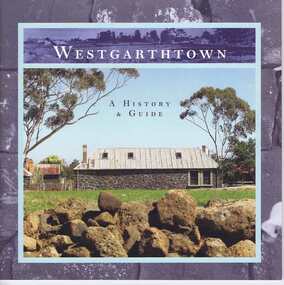 Greensborough Historical Society
Book, Westgarthtown: a history and guide, 2004_
... A short history of Westgarthtown (Thomastown Historic....) A short history of Westgarthtown (Thomastown Historic Precinct ...A short history of Westgarthtown (Thomastown Historic Precinct)Revised and enlarged edition. 44 p., illus. (some col.)westgarthtown -
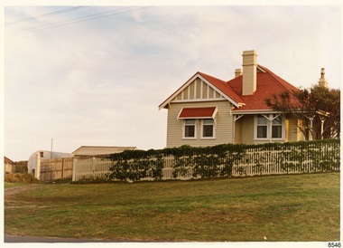 Flagstaff Hill Maritime Museum and Village
Photograph - Historical, Flagstaff Hill, Harbourmaster’s Quarters, 1970s
... that still stands on the east of the Lady Bay Lighthouse and Historic... that still stands on the east of the Lady Bay Lighthouse and Historic ...The photograph shows a cottage, Harbourmaster’s quarters that still stands on the east of the Lady Bay Lighthouse and Historic Precinct at Flagstaff Hill in Warrnambool. The name was changed to the Lighthouse Lodge, and today guests can stay at the property. This photograph, a print, is one of a set of five that show the site of Flagstaff Hill. It is presumed to have been taken by John Lindsay, Founding Director of Flagstaff Hill Maritime Museum and Village. One of the photographs in the set has the pencil inscription "Photo J Lindsay". It was taken in the early 1970s during the initial stages of the development of Flagstaff Hill as a Museum and Maritime Village. The photographs belonged to the donor's grandparents, who lived in the Warrnambool district of Allansford/Naringal. The photograph is a record of the site and surrounds of Flagstaff Hill Maritime Museum and Village before its development and opening in 1975. It shows the cottage on the east of the Lighthouse Complex,. The building is now known as Lighthouse Lodge. The photograph is significant for recording the location and condition of the residence on the Hill.Coloured photograph, glassy print, one of a set of five. Photograph shows the cream timber cottage, Harbourmaster’s quarters to the east of the lighthouse complex at Flagstaff Hill, Warrnambool. On the left of the red roofed residence are iron buildings used, at the time, by the Lands Department. The photograph's paper has the printer's watermark on the back. The early 1970s photograph is presumed to have been by John Lindsay, Warrnambool.Label on the back: "WOODEN RESIDENCE TO THE EAST OF THE PROPERTY / The gun emplacements are immediately behind, and the iron huts to the left rear of the residence are used by the Lands Department who plan to vacate, for other premises."flagstaff hill, flagstaff hill maritime museum and village, warrnambool, maritime museum, maritime village, great ocean road, shipwreck coast, 1970s, photograph, flagstaff hill site, john lindsay, cannon emplacement, residence, wooden residence, timber residence, iron huts, lands department -
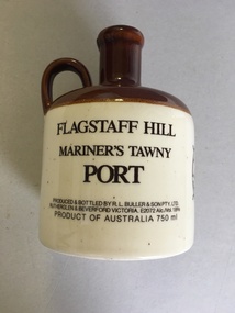 Warrnambool and District Historical Society Inc.
Flagon, R. L.Buller and Son Pty Ltd, Flagstaff Hill Maritime Village, 1970s
... of a Warrnambool historic precinct containing several original features... village and port built in the area of a Warrnambool historic ...This flagon which once contained 750 ml. of tawny port was sold at Flagstaff Hill Maritime Village in Warrnambool in the 1970s and perhaps the 1980s as a souvenir of the village and Warrnambool. Flagstaff Hill Maritime Village was opened in 1975 and is a re-created 19th century village and port built in the area of a Warrnambool historic precinct containing several original features from the 19th century. These include two operating lighthouses, lighthouse keepers’ quarters, chart room and a fortifications area with two cannons. As the village is a re-created port and includes a hotel called the Steam Packet Inn, the sale of a souvenir flagon of tawny port was most appropriate. Flagstaff Hill Maritime Village and Museum still operate today. This flagon is retained as an example of the souvenirs sold in Warrnambool some years ago to tourists visiting Warrnambool and Flagstaff Hill Maritime Village. This is a ceramic flagon with a cream body and a brown top and handle. The printing on the flagon is black and the flagon also has black printing of the logo of Flagstaff Hill Maritime Village. The flagon has no stopper.‘Flagstaff Hill Mariner’s Tawny Port’flagstaff hill maritime museum, warrnambool -
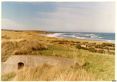 Flagstaff Hill Maritime Museum and Village
Photograph - Historical, Flagstaff Hill, Warrnambool Garrison Fortifications looking towards the Moyjil (Point Ritchie), 1970s
... of the Historic Precinct on Flagstaff Hill. The area was accessed either... of the Historic Precinct on Flagstaff Hill. The area was accessed either ...The photograph shows the location of the concrete, horseshoe shaped gun emplacement erected for the cannons. It is part of the Historic Precinct on Flagstaff Hill. The area was accessed either through the space between the Lighthouses (through the cottage grounds) or a service entrance, past the iron huts used by the Lands Department. This photograph, a print, is one of a set of five that show the site of Flagstaff Hill. It is presumed to have been taken by John Lindsay, Founding Director of Flagstaff Hill Maritime Museum and Village. One of the photographs in the set has the pencil inscription "Photo J Lindsay". It was taken in the early 1970s during the initial stages of the development of Flagstaff Hill as a Museum and Maritime Village. The photographs belonged to the donor's grandparents, who lived in the Warrnambool district of Allansford/Naringal. The photograph is a record of the site and surrounds of Flagstaff Hill Maritime Museum and Village before its development and opening in 1975. It shows the east side of the Surfside Holiday Park in its earlier days. The photograph is significant for recording the location and condition of the original concrete cannon emplacement on the Hill.Coloured photograph, glassy print, one of a set of five. Photograph shows the original site of one of the gun emplacements for the cannons, cannons Historical, looking towards the Moyjil, ,Point Ritchie and overlooking Lady Bay, Warrnambool. The horseshoe shaped concrete gun emplacement is in the foreground on the grassed slopes overlooking the Bay. The site and ablution block of the Surfside Holiday Park is centre right. The left shows the sore of Lady Bay with the cliffs of the Southern Ocean in the distance. The photograph's paper has the printer's watermark on the back. The early 1970s scene is presumed to have been photographed by John Lindsay, Warrnambool.Label on the back: "FIRST GUN EMPLACEMENT LOOKING TOWARDS THE HOPKINS / This is the original site of one of the cannons overlooking the Bay. Access to this area could be between the light-houses (throught the cottage grounds), or a service entrance - past the iron huts used by Lands Department."flagstaff hill, flagstaff hill maritime museum and village, warrnambool, maritime museum, maritime village, great ocean road, shipwreck coast, 1970s, photograph, gun emplacement, surfside holiday park, lady bay, hopkins river, flagstaff hill site, john lindsay, concrete gun emplacement, cannon emplacement, original emplacement -
 Forests Commission Retired Personnel Association (FCRPA)
Beechworth FCV District office sign
... Heritage Museum. The granite building in the Beechworth's historic... Heritage Museum. The granite building in the Beechworth's historic ...This sign proudly hung outside the Forests Commission Victoria (FCV) Beechworth office which is now site of the Forestry Heritage Museum. The granite building in the Beechworth's historic precinct was once the Gold Warden's Office and is one of the town's original buildings. The FCV was the main government authority responsible for management and protection of State forests in Victoria between 1918 and 1983. The Commission was responsible for ″forest policy, prevention and suppression of bushfires, issuing leases and licences, planting and thinning of forests, the development of plantations, reforestation, nurseries, forestry education, the development of commercial timber harvesting and marketing of produce, building and maintaining forest roads, provision of recreation facilities, protection of water, soils and wildlife, forest research and making recommendations on the acquisition or alienation of land for forest purposes″. The Forests Commission had a long and proud history of innovation and of managing Victoria's State forests but in September 1983 lost its discrete identity when it was merged into the newly formed Victorian Department of Conservation, Forests and Lands (CFL) along with the Crown Lands and Survey Department, National Park Service, Soil Conservation Authority and Fisheries and Wildlife Service. After the amalgamation the management of State forests and the forestry profession continued but the tempo of change accelerated, with many more departmental restructures occurring over the subsequent four decades. Responsibilities are currently split between the Department of Energy, Environment and Climate Action (DEECA), Forests Fire Management Victoria (FFMV), Parks Victoria, Melbourne Water, Alpine Resorts Commission, the State Government-owned commercial entity VicForests and the privately owned Hancock Victorian Plantations (HVP).Large office sign. Hand painted in traditional FCV mission brown and gold colour scheme. -
 The Beechworth Burke Museum
Postcard, 2005
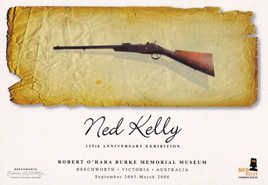
... / September 2005-2006 / BEECHWORTH / Echoes of History / HISTORIC... / BEECHWORTH / Echoes of History / HISTORIC & CULTURAL PRECINCT / NED ...To commemorate the 125th anniversary of Edward “Ned” Kelly’s committal trial in the Beechworth Historic Courthouse, the Robert O’Hara Burke Memorial Museum (henceforth Burke Museum) commissioned this postcard to coincide with their exhibition dating September 2005 to March 2006 and titled the Ned Kelly 125th Anniversary Exhibition. The postcard depicts a Snider-Enfield of .577 calibre which was reputedly favoured by the Bushranger. The firearm is of typical 1870s hunting design and was displayed as a focal point within this exhibition. The firearm, which was named “Betty” was reportedly taken by Kelly from Henry Dudley. The weapon has the letter ‘K’ engraved into the wood of the fore end. Other items also displayed in this exhibition include the Burke’s Kelly death mask, a replica of the Kelly Gang armour and photographs from the Burke Museum’s Kelly album. This postcard advertises an exhibition held at the Beechworth Burke Museum to commemorate the 125th anniversary of Kelly’s committal trial, which took place in Beechworth's historic courthouse. The selection and interpretation of items like the gun called 'Betty' are significant for understanding the changing nature of Kelly scholarship, treatment and curation, in particular, the popular and iconic myth of the Australian bushranger. The item can be compared with other Kelly photographs in Burke Museum's collection.Rectangular colour printed postcard celebrating Ned Kelly 125th Anniversary Exhibition at Burke Museum, Beechworth. Inset image of Ned Kelly's rifle. Obverse: Ned Kelly / 125th ANNIVERSARY EXHIBITION / ROBERT O'HARA BURKE MEMORIAL MUSEUM BEECHWORTH . VICTORIA . AUSTRALIA / September 2005-2006 / BEECHWORTH / Echoes of History / HISTORIC & CULTURAL PRECINCT / NED / KELLY / TOURING ROUTE / REVERSE: Ned Kelly / 125th ANNIVERSARY EXHIBITION / ROBERT O'HARA BURKE MEMORIAL MUSEUM BEECHWORTH . VICTORIA . AUSTRALIA / September 2005-2006 / AFFIX STAMP HERE / 7250 / This is the rifle that was taken from Henry Dudley by Ned Kelly. It became Ned's favourite / rifle, which he called 'Betty'. Note the 'K' carved into the wood of the fore-end. / Interestingly, there is at least one other rifle owned by Ned Kelly that also has a 'K' engraved / into it by Ned- the Colt revolving carbine used by Ned at Glenrowan /kelly album, ned kelly exhibition, ned kelly's rifle, betty, snider-enfield, .557 caliber, rifle, revolver, exhibition, beechworth, burke museum, 125th anniversary, firearm -
 Federation University Historical Collection
Booklet, University of Ballarat Centre for Environmental Management, 1996
The Centre for Environmental Management as established in July 1995 as a strategic development initiative to consolidate the University's position as a centre for industry linked environmenttal teaching, resarech and consultancy. Page 19 "SPECIAL INITIATIVES Establishment of field Research Stations Two areas of concentration of research effort for the Centre are the Otways in the south western Victoria and the Scotia Country in the rangelands of NSW. In both these areas it is essential that ther be a secure accomodation abase for research students. In the former case there is a need for a sheltered base to enable year round field work in cold wet conditions and in the latter a base with a reliable water supply and the facilities to allow field work in very hot dry conditions which prevail from much of the year. It has been an ibjective of the Centre to establish field stations at these two sites and considerable progress has been made through the year. (i) Nanya Field Station in the Scotial Country Through the generosity of the owner, Mr Rob Taylor, an unused homestead on Nanya Station was made available to the Centre. Largely through voluntary labour during research field trips during the year this previously derelict homestead has been restored to functionality and now has facilities for up to 20 research workers with a reliable water supply, cooking, washing, and refrigeration facilities. (ii) Cape Otway Resaerch Centre Negotiations have continued through the year with the potential lessees of the Cape Otway Lighthouse Precinct with the support of the Vice Chancellor and other potential user groups within the University these have reached a successful outcome. The University will be working with the lessees to develop the historic Telegraph Station as a dual purpose facility for interpretation and research." Black and white cover with clear plastic sheet. university of ballarat, centre for environmental management, martin westbrooke, richard mcewan, mal weston, john miller, nanya, telegraph station, cape otway, cape otway lighthouse station, cape otway telegraph station, field resaerch stations, s. hadden, peter dahlhaus, r.j. macewan, pat prevett, native vegetation assessment, fauna management, pest plants and animal research, soil and water assessment, conservation reserve management, paul ryan, richard macewan -
 Surrey Hills Historical Society Collection
Book, City of Whitehorse Heritage Review (as it relates to Surrey Hills), 1999
A street by street survey of each of the proposed precincts was undertaken. For each precinct, building fabric was defined in terms of intactness, scale, construction type, architect and predominant eras of construction.A street by street survey of each of the proposed precincts was undertaken. For each precinct, building fabric was defined in terms of intactness, scale, construction type, architect and predominant eras of construction.cultural property, protection of historic sites, heritage overlay precincts, heritage review, building citations -
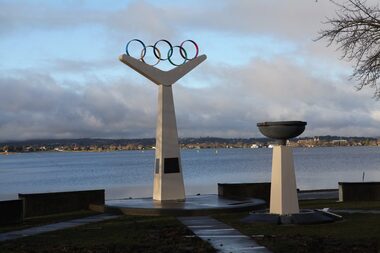 City of Ballarat
Artwork, other - Public Memorial, Olympic Monument
The Olympic precinct redevelopment was driven by a group of Ballarat Olympians to commemorate 50 years since the 1956 Olympic rowing events on Lake Wendouree. The memorial highlights the values of the Olympic movement and honours Ballarat Olympians by bronze casts of hands or feet. The memorial was constructed by Ballarat builder H. Troon using the Olympic rings as the focal point.The monument is of historic and social significance to the people of BallaratWhite stone monument mounted with Olympic rings"The most important thing in the Olympic Games is not to win but to take part, just as the most important thing in life is not the triumph, but the struggle. The essential thing is not to have conquered, but to have fought well."olympic games, 1956 olympic -
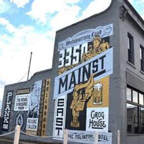 City of Ballarat
Artwork, other - Public Artwork, Travis Price, Main Road Mural by Travis Price, May 2018
Whilst my main focus for the artwork design was on the Hotels on Main Road, I felt there was an opportunity to tell a broader story of Main Rd and combine/include some interesting pieces of information from many stages of the history of Main Road. Considering that at one point in time there would have been at more than six hotels in this very short section of street….there’s no doubt Main Rd was an epicentre of communication and festivities for the Goldfields of Ballarat. “No matter what luck he had, every miner needed supplies, food and something to entertain him when he was not searching for gold.” Described as being an overcrowded jumble of muddy streets loosely arranged around mining camps...and loud, muddy, colourful and sometimes illicit. I wanted the artwork composition to consist of overlapping images and text to reflect this sense of hustle and bustle. Main Road Mural tells the broader story of the history of Main Road in Ballarat. In 2018, the City of Ballarat commissioned local Ballarat artist Travis Price to create an artwork to align with the Main Road Revitalisation Project and deliver a key component of the storytelling (heritage interpretation) project that spans the length of the shopping precinct. The artwork is featured on a prominent site in the shopping precinct of main road and tells the story of Main Road through depicting key timeline events. Main Road, as its name suggests, was one of the main entries to the mining areas of East Ballarat. It had several names: Main Street before 1858, Plank Road between 1858 and 1868 and Main Road from 1868 onwards. The centre of mining life, it was crowded, prosperous, raucous and dirty. Painted mural on shop wall in Main Road, BallaratBallaarat, Gold Fever, The Royal Standard Hotel, Flood, Boxing Saloon, Plank Road, Kulin Nation, 3350, Election, East, Grog House, The Scandinavian Hotel. Images; Chinese lantern, Pick & Shovel, Miners Licence burning.main road history, ballarat hotels, gold fever, wadawurrung, kulin nation -
![EJ Harvey, Motor Engineers, High Street [Kew East], circa 1925](https://victoriancollections.net.au/media/collectors/550653872162f11fb04854aa/items/586f9929d0ce2607f0b81f1a/item-media/586f99e0d0ce2607f0b8546f/item-fit-380x285.jpg) Kew Historical Society Inc
Kew Historical Society IncPhotograph - Photograph [copy], EJ Harvey, Motor Engineers, High Street [Kew East], circa 1925, c. 1925
The building was in High Street, Kew East between Clyde and Oswin Streets. The site is currently (2017) occupied by a canoe retailer.Rare and historic photograph of an early business in the Harp Village shopping precinctGarage - E.J. Harvey, Motor Engineers workshop, High Street, East Kew. The garage was on the corner of Clyde Street.Inscription reverse: "High Street, East Kew - present site of Harvey Phillips Retro Vision[*] shop. Gift of Edna Phillips. Edna loaned KHS the original photo and KHS had it copied." * Note - Harvey Phillips Retravision not Retro Vision].motor engineers (kew), garages (kew), e.j. harvey -
Whitehorse Historical Society Inc.
Document, Thomas Street Precinct Mitcham, n.d
... Mitcham melbourne Document Document Thomas Street Precinct Mitcham ...Statement of historic significance of housing in the Thomas Street area.Statement of historic significance of housing in the Thomas Street area, principally Californian bungalows.Statement of historic significance of housing in the Thomas Street area.thomas street mitcham, city of whitehorse heritage review 2002, californian bungalows -
Federation University Historical Collection
Poster, University of Ballarat Camp Street Campus, 2000
The University of Ballarat became Federation University Australia in 2014. The Camp Street Campus was later known as the Arts Academy. Framed poster of a collage of images showing plans for the University of Ballarat Camp Street Campus, later known as the Arts Academy. "In acknowledgement of the joint agreement to redevelop historic camp Street as a dynamic arts precinct utilising the central business district area of Ballarat."arts academy, camp street precinct, camp street, arts precinct -
 Eltham District Historical Society Inc
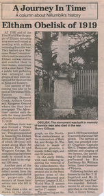
Photograph, Eltham War Memorial 1914-1918. Cnr. Main Road and Bridge Street, 3 August 1919
Dated 1919, the Eltham Obelisk is decorated with wreaths, most likely for what was originally known as Armistice Day though now known as Remembrance Day, 11 November. The location of the Obelisk at the corner of Bridge Street and Main Road became known as Obelisk Corner and the Bridge Street bridge was also referred to as Obelisk Bridge. The Eltham Obelisk was originally located at the corner of Bridge and Main Roads in 1919. In 1943 (WW2) the local community commenced plans to establish the Eltham War Memorial, a living memorial to benefit the children as opposed to a one in stone as per the obelisk. The Eltham War Memorial Trust was established in 1945. In 1947 the Trust intended for the Obelisk to be relocated from Bridge Street and Main Road to the Garden of Remembrance which was planned as part of the Baby Health Centre which was to be the first of three buildings of the Eltham War Memorial to be built in 1951. In 1951 the Eltham RSL was invited to be represented on the Eltham War Memorial Trust. Around this time, with pending roadworks, the obelisk was relocated to the front garden of the Eltham RSL sub branch on Main Road for safe keeping. In 2007, a suggestion was proposed by Harry Gilham (President, EDHS) to John Cohen (ERSL) to claim a special site along with the historic Shillinglaw trees on the now vacant former Eltham Shire Office site adjacent to the Eltham War Memorial precinct for relocation of the obelisk. In 2010 following the financial collapse and sale of the Eltham RSL Sub-Branch property and amalgamation with the Montmorency Eltham RSL sub-branch, the location of the obelisk was again in immediate jepoardy and in conjunction with Nillumbik Shire Council, the obelisk was relocated in front of the Eltham War Memorial buildings in preparation for the Dawn Service on Anzac Day 2012.This photo forms part of a collection of photographs gathered by the Shire of Eltham for their centenary project book,"Pioneers and Painters: 100 years of the Shire of Eltham" by Alan Marshall (1971). The collection of over 500 images is held in partnership between Eltham District Historical Society and Yarra Plenty Regional Library (Eltham Library) and is now formally known as 'The Shire of Eltham Pioneers Photograph Collection.' It is significant in being the first community sourced collection representing the places and people of the Shire's first one hundred years.Digital image 4 x 5 inch B&W Negsepp, shire of eltham pioneers photograph collection, eltham, main road, bridge street, eltham war memorial, obelisk, obelisk corner, wreath -
 Eltham District Historical Society Inc
Negative - Photograph, Eltham War Memorial Obelisk 1914-1918, cnr. Main Road and Bridge Street, c.1925
Located on what was referred to as Obelisk Corner, improvements have been been made since the unveiling in August 1919 with the provision of a stone retaining wall topped with a chain link and granite stone boundary, most likely in conjunction with improvements to the intersection into Main Road. Along with the use of the name Obelisk Corner, the Bridge Street bridge was also known as Obelisk Bridge. The Eltham Obelisk was originally located at the corner of Bridge and Main Roads in 1919. In 1943 (WW2) the local community commenced plans to establish the Eltham War Memorial, a living memorial to benefit the children as opposed to a one in stone as per the obelisk. The Eltham War Memorial Trust was established in 1945. In 1947 the Trust intended for the Obelisk to be relocated from Bridge Street and Main Road to the Garden of Remembrance which was planned as part of the Baby Health Centre which was to be the first of three buildings of the Eltham War Memorial to be built in 1951. In 1951 the Eltham RSL was invited to be represented on the Eltham War Memorial Trust. Around this time, with pending roadworks, the obelisk was relocated to the front garden of the Eltham RSL sub branch on Main Road for safe keeping. In 2007, a suggestion was proposed by Harry Gilham (President, EDHS) to John Cohen (ERSL) to claim a special site along with the historic Shillinglaw trees on the now vacant former Eltham Shire Office site adjacent to the Eltham War Memorial precinct for relocation of the obelisk. In 2010 following the financial collapse and sale of the Eltham RSL Sub-Branch property and amalgamation with the Montmorency Eltham RSL sub-branch, the location of the obelisk was again in immediate jepoardy and in conjunction with Nillumbik Shire Council, the obelisk was relocated in front of the Eltham War Memorial buildings in preparation for the Dawn Service on Anzac Day 2012.This photo forms part of a collection of photographs gathered by the Shire of Eltham for their centenary project book,"Pioneers and Painters: 100 years of the Shire of Eltham" by Alan Marshall (1971). The collection of over 500 images is held in partnership between Eltham District Historical Society and Yarra Plenty Regional Library (Eltham Library) and is now formally known as the 'The Shire of Eltham Pioneers Photograph Collection.' It is significant in being the first community sourced collection representing the places and people of the Shire's first one hundred years.Digital image 4 x 5 inch B&W Negsepp, shire of eltham pioneers photograph collection, eltham, main road, eltham war memorial, bridge street, obelisk, obelisk corner -
 Melbourne Water
Transparency, Staff and Chauffeurs at the O'Shannassy Weir Quarters, 8th April, 1921
The O'Shannassy Weir was a small Weir created in 1911 and completed in 1913, and was the originating point of outflow into the Aqueduct. In 1928, it was replaced by the much larger O'Shannassy Reservoir. The Weir had water moving along the Aqueduct to the Surrey Hills Reservoir. Many structures at the Weir precinct have survived and remain in-situ.The O'shannassy Weir and Aqueduct contains a wide range of intact and diverse features. This demonstrates the way in which the Board constructed and managed the water supply that flowed through farmland and forest areas subject to timber milling. The caretakers residences that are located along the aqueduct were utilised by caretakers who were responsible for maintaining one of their four sections of the channel. This transparency is significant for its historic association to the establishment of the weir and to those who worked on the project, and at the quarters. weir, o'shannassy, aqueduct, reservoir, melbourne water, mmbw, staff -
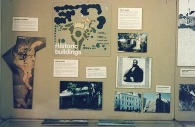 Churchill Island Heritage Farm
Photograph - Photograph of Visitor's Centre Display
Churchill Island Heritage Farm has a large photograph collection dating from the nineteenth century. Photograph of Visitor's Centre Display showing historic buildings, a map of the Heritage PrecinctCatalogue number on reverse in pencil.churchill island, photograph -
 Eltham District Historical Society Inc
Folder, Eltham Obelisk (later Cenotaph), 1918-2018
The Eltham Obelisk was originally located at the corner of Bridge and Main Roads in 1919. In 1943 (WW2) the local community commenced plans to establish the Eltham War Memorial, a living memorial to benefit the children as opposed to a one in stone as per the obelisk. The Eltham War Memorial Trust was established in 1945. In 1947 the Trust intended for the Obelisk to be relocated from Bridge Street and Main Road to the Garden of Remembrance which was planned as part of the Baby Health Centre which was to be the first of three buildings of the Eltham War Memorial to be built in 1951. In 1951 the Eltham RSL was invited to be represented on the Eltham War Memorial Trust. Around this time, with pending roadworks, the obelisk was relocated to the front garden of the Eltham RSL sub branch on Main Road for safe keeping. In 2007, a suggestion was proposed by Harry Gilham (President, EDHS) to John Cohen (ERSL) to claim a special site along with the historic Shillinglaw trees on the now vacant former Eltham Shire Office site adjacent to the Eltham War Memorial precinct for relocation of the obelisk. In 2010 following the financial collapse and sale of the Eltham RSL Sub-Branch property and amalgamation with the Montmorency Eltham RSL sub-branch, the location of the obelisk was again in immediate jepoardy and in conjunction with Nillumbik Shire Council, the obelisk was relocated in front of the Eltham War Memorial buildings in preparation for the Dawn Service on Anzac Day 2012. Contents: Newspaper article: Eltham Obelisk of 1919, Harry Gilham, August 2000 as well as draft submitted dated 22 Aug 2000 Newspaper article: Eltham, The Advertiser 15 Nov 1918 and 18 Nov 1918 Newspaper article: An Obelisk at Eltham, The Advertiser, 11 Jul 1919 Newspaper advertisement: Unveiling of Obelisk at Eltham, The Advertiser, 1 Aug 1919 Newspaper article: Eltham Soldiers’ Memorial; Unveiled by Sir William Irvine, The Argus, Monday, 4 Aug 1919, p8 Newspaper article: Eltham Memorial to Fallen Soldiers, Diamond Creek Valley Advocate, 8 Aug 1919 Newspaper article: Memorial to the Fallen; Unveiled at Eltham, The Age, Monday, 4th August 1919 Newspaper article: Programme - Presentation of German Machine Gun at the Obelisk, Eltham on Sunday, 8th August, 1920, at 3.30 P.M. Newspaper article: article about presentation of a war trophy, a heavy machine gun placed beside obelisk, The Advertiser, 13 Aug 1920 Newspaper article: Eltham: ANZAC Services, The Advertiser, Friday, May 2, 1924 Newspaper article: Eltham War Memorial, The Advertiser, Oct 26, 1928 Handwritten note from Harry Gilham (President EDHS) to John Cohen (ERSL) regarding history of Eltham RSL site and 1947 newspaper article "Eltham War Memorial Trust "Garden of Remembrance" referencing relocation of Obelisk to the proposed Garden of Remembrance at the Baby Health Centre (Eltham War Memorial). Officers' reports, 11.113/10 Relocation of Eltham RSL Cenotaph, Nillumbik Shire Council Ordinary Meeting, 21 December 2010 Email Correspondence: EDHS President to NSC General Manager Community and Leisure re RSL Obelisk (Cenotaph) proposed relocation, 24 May 2011 Newsletter Extract: Eltham RSL and War Memorial, EDHS Newsletter 14 Sep 2011 Officers' reports, OCM.091/11 Interim Relocation site for the Eltham Cenotaph, Nillumbik Shire Council Ordinary Meeting, 23 August 2011 Officers' reports, OCM.004/121 Interim Relocation of the Eltham Cenotaph, Nillumbik Shire Council Ordinary Meeting, 31 January 2012 (includes Funding agreement between NSC and Montmorency-Eltham RSL Sub-branch Inc) Newspaper article: Move war memorial: RSL, c.2011 Newspaper article: Memorial move lags, Diamond Valley Leader, 1 February 2012 Newspaper article: New dawn for tribute, Diamond Valley Leader ca April 2012 Open letter to the residents of Eltham and Montmorency and copies of drafts by the Montmorency Eltham RSL, no date and final version published in Diamond Valley New 21 March 2012 and Banyule & Nillumbik Weekly, 27 March, 2012 Newspaper article: RSL site nets $1.8m, Diamond Valley Leader, 9 May 2012 Newspaper article: Memorial Moved, Banyule/Nillumbik Weekly, 10 April 2012 Newspaper article: Eltham cenotaph move goes 'like clockwork', Diamond Valley Leader, 11 April 2012 Advertisement, Program for Eltham Dawn Service, Diamond Valley Leader, April 2012 Newspaper photo: Veterans (l-r) Alan Field, Max Lowerson and John Cohen will join piper David Cretney to commemorate fallen Diggers, 2012 (standing beside relocated obelisk in front of the Eltham War Memorial complex) Program for Montmorency Anzac Day March 2012 (incomplete, some pages duplicated, some pages upside down). Newspaper article: Plan to expand memorial, Diamond Valley Leader, Sep. 2004, p5 Newspaper article: Names renewal, thanks to Barry, Diamond Valley Leader, 18 Apr 2007, p3 with picture featuring Eltham RSL president John Haines and Gwen Rosewall Letter: EDHS President to Manager Community Participation, Learning and Culture, Nillumbik Shire Council regarding a proposal by the Montmorency-Eltham RSL Sub-branch to expand the area occupied by the relocated obelisk further into the Eltham War Memorial Garden of Remembrance, 18 Aug 2014 Notices of Motion, NOM.001/14 pertaining to memorials Advisory Committee and Montmorency-Eltham RSL to upgrade the Eltham War Memorial site in time for ANZAC Day 2015, Nillumbik Shire Council Ordinary Meeting, 26 August 2014 Agenda: User Groups and Stakeholders Meeting, Proposed Extension to Memorial Terrace, 11 September 2014 EDHS presentation to NSC Policy and Services meeting 9 September 2014 regarding the Montmorency-Eltham RSL proposal to expand/upgrade the Eltham War Memorial Policy and Services reports, PSD.034/14 Eltham War Memorial Building Precinct - Proposed Extension to Memorial Terrace, Nillumbik Shire Council Ordinary Meeting, 9 September 2014 Email (copy): President EDHS re Eltham War Memorial Complex, Main Road, Eltham, 15 Sep 2014 requesting Nillumbik Shire Council place a Heritage Overlay upon the Eltham War Memorial Complex Media Release: Support for cenotaph expansion, Nillumbik Shire Council, Sep 2014 Newspaper article: Council defers RSL war memorial upgrade to see consultation, Diamond Valley News, 17 Sep 2014 Letter (copy): Harry Gilham, Eltham to local press and others, 20 Sep 2014 protesting attempts by the RSL to further expand upon the area already ceded from the Eltham War Memorial for the relocated WW1 obelisk and alter the original vision for an Eltham War Memorial complex. Letter: Alan Field, President, The Eltham Veterans War Memorial Preservation Society Inc. to CEO and Councillors, Nillumbik Shire Council protesting at perceived injustices and ‘veteran bashing’ regarding their previous efforts to relocate ‘their Obelisk and Cenotaph’ to the Eltham War Memorial complex and their frustration in their attempts to further expand upon the Memorial Terrace. Areas of letter are highlighted with handwritten markups and notes. Also notes on loose card and paper with definitions of Memorial, Obelisk, Cenotaph, commentary on establishment of Eltham War Memorial, The Eltham War Memorial Trust and RSL involvement and current actions by RSL in respect to claims in the letter (written by Harry Gilham ?). Policy and Services reports, PS.038/14 Eltham War Memorial Building Precinct - proposed extension to the Eltham Cenotaph Terrace, Nillumbik Shire Council Policy and Services Committee Meeting, 14 October 2014 Newspaper article: Centenary dawn service moves to Petrie Park, Diamond Valley Leader, 22 Oct 2014 Newspaper article: Upset over upgrade; war memorial revamp plans get culled, Diamond Valley Leader, 29 Oct 2014 Newspaper article: Memories of our heroes, Diamond Valley Leader, 25 Apr 2018 – also Veteran saluted, featuring article on Army veteran, Glen Ferrarotto. Handwritten notes in pencil (2 pages) by Harry Gilham, Items form the Eltham and Whittlesea Shires The Advertiser newspaper 7 June 1918 - 1919 providing a summary of the formation of the Peace Celebration Committee leading to the establishment of the Avenue of Honour and the Eltham Obeliskeltham cenotaph, nillumbik shire council, eltham war memorial, montmorency eltham rsl sub-branch, dawn service, cenotaph, eltham rsl sub-branch, eltham war memorial trust, garden of remembrance, harry gilham collection, john cohen, obelisk, remembrance garden, shillinglaw trees, german machine gun, war memorial, war trophy -
 Wooragee Landcare Group
Photograph, 2004
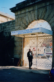
This photo was taken in 2004 and pictures Greg Johnson, who worked at Agriculture Victoria (formerly known as the Department of Primary Industries, DPI), outside Beechworth Prison. This was the last year Wooragee Landcare Group met with Beechworth Prison Farm and Industry Managers at the prison itself, where they discussed weed and rabbit control on the prison's 'Rockery' block. The weed and rabbit controls that were explored in this event aimed to educate people on how to manage common pests in the Wooragee landscape and improve the appearance of the Beechworth Prison. The Beechworth prison itself is significant as it was built between 1859 and 1864 and is designed using a radiating 'panopticon' method which had proved an efficient, cost-effective design for easy surveillance of prisoners by allowing guards to watch over a large area from a central observation point. The prison is historically significant for its association with the early development of Beechworth as the government administrative centre of north-eastern Victoria. It is part of a major precinct of public buildings and has links to numerous other places in Beechworth which used granite quarried and broken at the prison by male inmates. It is also significant for its associations with the bushranger Ned Kelly and the Kelly storyThe photo holds significance due to the social and educational context the image holds in representing the events Wooragee Landcare Group held in order to educate the public. The photograph also exemplifies the historic significance of the area due to the Beechworth Prison's relation to important historical eras and events.Portrait coloured photograph printed on gloss paperReverse: WAN NA E0NA0N2. NNN- 3 2906 / [PRINTED] (No.13) / 868wooragee, wooragee landcare, wooragee landcare group, beechworth prison, h.m beechworth prison, beechwoth gaol, ned kelly, greg johnson, agriculture victoria, department of primary industries, dpi -
 Kew Historical Society Inc
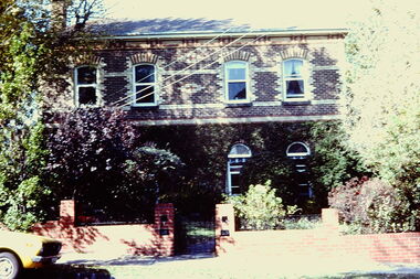
Slide - 4 Selbourne Road, Kew, 1979
One of a group of slides taken by members of the Society of built heritage in Kew in 1979-80. The selection of subject matter reflects the priorities of the period. The colour of some slides has degraded.The slides represent a snapshot in time of built architecture in Kew, much of which has changed in the forty-plus period since they were created.Colour positive transparency (slide) of 4 Selbourne Road, Kew, the former home of Sir Wilfred Kent-Hughes (1895-1970) who was the State Member for Kew from 1927-1949. Subsequently he was elected to the Federal Parliament as the Member for Chisholm. The two-storey, double fronted, polychrome brick house is within the City of Boroondara's Glenferrie Road Precinct, which includes a number of individually significant architectural designs, the majority of which are Victorian mansions.historic houses -- kew (vic.), 4 selbourne road -- kew (vic.), sir wilfred kent-hughes